Review of Harvest Green

I recently took a drive through Harvest Green, a master planned community located in Richmond, Texas. Currently being developed by the Johnson Development Corporation it features agriculture and gardening as a central theme. Amenities include a working farm; optional backyard raised bed gardens; a trail system; herb gardens in some common areas; lakes; and a fitness center with pool, splash pad, and playground. I toured the community to review its drainage system, and amenities, and to see how the two were integrated.

The master planned community will eventually occupy 1,300 acres; however, only the first few sections have been completed thus far. This is an illustration of the complete master plan.

Masterplan obtained from online development literature. https://www.harvestgreentexas.com/masterplan

In some locations the four lane main roads drain to depressed areas planted with native grasses and shrubs that provide some detention and retention of stormwater (see below). I was unable to tell if these areas subsequently drain directly to underground storm sewers and then to a detention basin or if the drainage flows through a bioretention system first. I was also unable to tell if including these areas allowed the development to proceed with a lower volume of centralized detention. [If anyone involved in the design of this project knows, please leave a comment.]

Photograph by M. Bloom.

Each of these low areas has educational signage identifying it as a “Native Meadow” (see below). This helps residents and visitors, who may be used to a more formal and manicured type of landscaping, know that the tall prairie grass and wildflowers are intentional and are part of the “natural” and “wild” Harvest Green experience and brand.

Photograph by M. Bloom.

Many of the homes have backyards adjacent to trail or creek corridors. The photograph below shows a trail along Oyster Creek. Homes along this corridor have an open fence design along back lot lines. I did not notice if gates were provided for easy home owner access to the trail system. Landscaping includes a mix of both mowed turf grass and unmowed “wild” areas with native grasses and flowers.

Photograph by M. Bloom.

Some creek corridors don’t currently include trails and are not served by backyard gates. The photograph below shows an example of this. This is a bit of a missed opportunity to integrate both natural amenities and natural drainage into these corridors.

Photograph by M. Bloom.

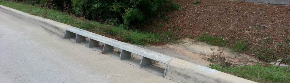
While some of the main roads appear to drain to natural systems, local residential streets do not. All of the local streets appear to be served by traditional curb and gutter drainage systems with underground pipes flowing to centralized detention basins. The basins were built deeper than required for detention purposes and were clay lined so that they hold some permanent water and serve as amenity lakes.  The photograph below shows the traditional raised curb and a pair of side-by-side curb inlets. As noted previously, the more extensive use of natural drainage systems can reduce the need for end-of-pipe detention systems. I was not able to tell if Harvest Green was able to take advantage of that benefit.

Photograph by M. Bloom.

A recycled water system has been added to the community’s wastewater treatment system and recycled water lines have been installed throughout the development to be used for landscape and farm irrigation. State rules require the recycled water piping system be purple and signage be installed to reduce the risk of people drinking the recycled water. The quality of the water is perfectly safe for watering food crops, but it is not intended for direct human consumption. See photograph below.

Photograph by M. Bloom.

Like most suburban communities in the region, the entry points are marked with large, illuminated, entry monuments and signage.  The photograph below shows one of the entry monuments to Harvest Green.

Photograph by M. Bloom.

But this monument is a bit unusual. It is solar powered! The photograph below shows the photovoltaic cells and what I assume is a battery system of some kind.

Photograph by M. Bloom.

The Johnson Development Corporation and their design team used natural drainage approaches to manage the runoff from some areas of the master planned community. They integrated amenities and drainage system in some areas. They deployed non-potable water reuse systems and solar systems to improve the sustainability of the development.

Their marketing of the community has focused on the natural amenities, agricultural features, and gardening elements to differentiate their offering to home buyers, some of whom are looking for a more active and engaged lifestyle and to live in a more sustainable and environmental friendly community.

The Johnson Development Corporation (and their planning and design professionals) should be commended for what they have accomplished in Harvest Green.

The Invisible Development

Can we make our land development projects (hydrologically) invisible to downstream properties?  Think of Claude Rains, in the 1933 film adaptation of the H. G. Wells novel, The Invisible Man.

“If I work in the rain, the water can be
seen on my head and shoulders.
In a fog, you can see me – like a bubble.
In smoky cities, the soot settles on
me until you can see a dark outline.”

— The Invisible Man, 1933

I believe we can, using a natural drainage approach.  To illustrate this we must think through some basic — no actual math required! — hydrology.

Imagine a rectangular area of undeveloped land that has a gradual slope from one corner to another.  Imagine that all rain falling on this land drains to the low corner and rain falling outside of this area drains to some other location.  Like this:

Imagine that before we develop the site – the “predevelopment” condition – we install a flow measuring device to the low point. This allows us to record the stormwater runoff flow rate leaving the predevelopment site.

If we did this, one hour before a 10 minute rain event, for example, the runoff flow rate would be 0 gallons per minute (gpm). As the first drops of the 10 minute rain hit the ground, the flow would be 0 gpm. Minutes and hours later, the flow would reach its peak and then start to decline back down to 0, like this:

The graph above displays the predevelopment hydrograph.  All plots of stormwater runoff flow rate vs. time are known as hydrographs. If we know the history of the flow rate vs. time, we can easily determine the total volume of runoff that left the site as a result of our 10-minute rain.  The total runoff volume, if you recall your calculus, is the area under the curve, like this:

This makes sense because if we multiply the dimensions of the x-axis expressed in minutes by the flow rate expressed in gallons per minute we get gallons because the minutes cancel out:

Minutes x Gallons / Minute = Gallons

If we add some kind of development (buildings, roofs, roads, etc.) to the site, thereby increasing the site impervious, the runoff hydrograph changes.  The added smooth hard surfaces and concrete storm sewers:

  • Reduce resistance to flow;
  • Eliminate nooks and crannies for surface storage;
  • Accelerate the timing of the runoff;
  • Reduce or eliminate water infiltration; and,
  • Reduce or eliminate water transpiration (consumption and release to the atmosphere by plants).

These changes to the drainage area change the hydrograph that would be produced if the exact same 10 minute rain event fell on the post-development site.  The post-development hydrograph might look something like this:

Note the following characteristics:

  • Higher peak flow;
  • Earlier peak flow;
  • Faster decline back to zero flow; and,
  • Larger total volume of runoff.

Well that can’t be good, right?

If we developed this way the bayou receiving this runoff water would see a higher flow rate. This would result in a higher water level, which might cause downstream flooding if that higher water level was higher than the top of the bayou banks.

We mitigate the effect by sizing and constructing detention basins downstream of all new development. The detention volume is generally equal to the “excess volume” produced by the development. The “excess volume” is determined by calculating the difference between the pre- and post-development runoff volumes, like this:

The light blue is the difference between the two ares (volumes).  We can place that volume of stormwater runoff anywhere we’d like on the site. Engineers love making them into the shape of nice, regular, rectangles, like this:

Landscape architects have encouraged us to make them into more natural shapes. Regardless of their shape, they are designed to hold the excess volume and to release that water at a rate that does not exceed the predevelopment peak flow rate, like this:

This prevents downstream flooding, but its not perfect. Can you see a few of the problems with this approach?

The main problem is the volume of runoff is not reduced. With detention, the site discharges at the predevelopment peak flow rate for a longer period of time.  (Compare the horizontal distance of the blue line to the brown line.)  Compare the brown area (predevelopment runoff volume) to the blue area (post-development runoff volume), below:

So how can we deal with this extra volume?

Natural drainage systems (also known as “low impact development”) can help address this. Natural drainage systems are installed to slow the water down, infiltrate water, evaporate water, store water in small or micro scale detention areas, transpirate water, and generally to mimic the predevelopment hydrology. The same rain event falling on the site – mitigated with a natural drainage approach – might produce a hydrograph that looks more like the green hydrograph below: 

So how does the runoff volume comparison look using natural drainage? 

Pretty good, huh?

The natural drainage approach seeks match the predevelopment hydrology.  This means that the downstream folks experience no difference in the timing, rate, or volume of runoff (for a given rainfall event).

Some natural drainage proponents, like me, like to say the development is hydrologically invisible.